 Wollumbin Summit Track
Visitor Safety
Risk Assessment
Wollumbin Summit Track
Visitor Safety
Risk Assessment
Image: Stuart Owen Fox; Destination NSW
September 2019
link to page 3 link to page 3 link to page 3 link to page 5 link to page 5 link to page 8 link to page 11 link to page 14 link to page 18 link to page 18 link to page 20 link to page 20 link to page 22 link to page 22 link to page 23 link to page 24 link to page 24 link to page 25 link to page 25 link to page 25 link to page 26 link to page 26 link to page 27 link to page 28 link to page 28 link to page 29 link to page 31 link to page 31 link to page 33
Table of Contents
1.
Introduction ............................................................................................................................. 1
2.
Objectives ............................................................................................................................... 1
3.
Wollumbin summit Track Description ..................................................................................... 1
4.
Cultural and natural heritage values ....................................................................................... 3
5.
Visitation and tourism values .................................................................................................. 3
6.
Recorded injuries and fatalities .............................................................................................. 6
7.
Legal and Policy considerations ............................................................................................. 9
8.
Hazard identification and Risk assessment .......................................................................... 12
9.
Detailed Risk assessments ................................................................................................. .16
Risk 1. Hazardous trees or branches falling on walker(s) causing serious injury or fatality…… 16
Risk 2 Rock fall, landslide, cliff or slope instability along the track causing serious injury or
fatality to walker(s)……………………………………………………………………………………...18
Risk 3 Slips, trips or falls due to rough surfaces, exposed roots, creek crossings, wet ground
etc. causing serious injury or fatality to walker(s)…………………………………………………... 20
Risk 4 Walker(s) leaving the track and becoming lost leading to serious injury………………… 21
Risk 5 Lack of walker skill, experience or health condition leading to serious injury, illness or
fatality…………………………………………………………………………………………………… 22
Risk 6 Walker(s) exposed to extreme weather (heat, cold, heavy rainfall and thunderstorms)
conditions resulting in serious illness (ie heat stroke, heat exhaustion, dehydration or
hypothermia) or serious injury (lightning strike)…………………………………………………….. 23
Risk 7 Walker(s) bitten or stung by snakes, spiders, ticks or insects resulting in serious illness
or fatality………………………………………………………………………………………………… 24
Risk 8 Delays in emergency response to lost or injured walker(s)……………………………….. 25
Risk 9 Built asset (elevated platforms, handrails, constructed pathway) failure causing serious
injury or fatality to walker(s)…………………………………………………………………………... 26
Risk 10 Failure of the chain and anchor system causing serious injury or fatality to walker(s). 27
Risk 11 Slips, trips or falls ascending and descending the chain section causing serious injury
or fatality to walker(s)………………………………………………………………………………….. 29
10.
References ........................................................................................................................... 31
Appendix 1 Health and Safety Risk Matrix……………………………………………………………..32
Wollumbin Summit Track Visitor Safety Risk Assessment – Confidential Final Report September 2019
1. INTRODUCTION
The NSW National Parks and Wildlife Service (NPWS) has a duty to consider the safety of visitors
to national parks and is required to take steps to ensure that risks are appropriately managed. This
requirement relates to NPWS’s role as a land manager and its obligations to visitors and to NPWS
staff and contractors.
NPWS aims to provide visitors with a safe and enjoyable experience. However, the natural
environment will always present risks to visitors—these risks can be managed, but never eliminated.
This ‘Wollumbin Summit Track Visitor Safety Risk Assessment’ has been undertaken in accordance
with the NPWS risk management framework, specifically the
OEH Risk Management Policy (OEH
2018) and the
OEH Risk Management Procedures (OEH, 2019),
NPWS Visitor Safety Policy (NPWS, 2013); and by applying the OEH
Health & Safety Risk Matrix (OEH, 2017).
This assessment has been undertaken by Siân Waythe, Senior Project Officer, Risk, Compliance
and Sustainability of the NPWS Safety and Business Performance Team for NPWS’ Tweed Byron
Area. Assessments were made using the best available information be that published work, agency
records or anecdotal advice.
This risk assessment does not address the safety of park staff and contractors working on the
Wollumbin Summit Track.
2. OBJECTIVES
The objectives of the risk assessment are to:
•
Identify visitor safety risks associated with the visitor use of the Wollumbin Summit Track.
•
Analyse these risks to determine the level of risk.
•
Advise on options to mitigate identified risks.
3. WOLLUMBIN SUMMIT TRACK DESCRIPTION
Location
The Wollumbin Summit Track is located with Wollumbin National Park, 12km south-west of
Murwillumbah in north-eastern NSW.
Management responsibility
The Wollumbin Summit Track is managed by the Tweed - Byron Area for NPWS. Wollumbin
National Park is not a co-managed park but the Bundjalung People, represented by the Wollumbin
Consultative Group, have a strong interest in the management of the mountain. They are opposed
to walkers accessing the summit.
Track length
The track is approximately 8.8 kilometres in length (return trip), starting from the Breakfast Creek
carpark. The route is up and back on the one track (ie no loop). The return trip (takes 4 to 6 hours,
depending on the speed of travel fitness of the walkers. The steepest and most challenging section
is the final 30 minutes of the assent 100m to the summit, where climbers use chains to ascend and
descend over the rockface. The track rises 720m in altitude to the summit at 1096m.
Wollumbin Summit Track Risk Assessment – Confidential Final Report September 2019
1
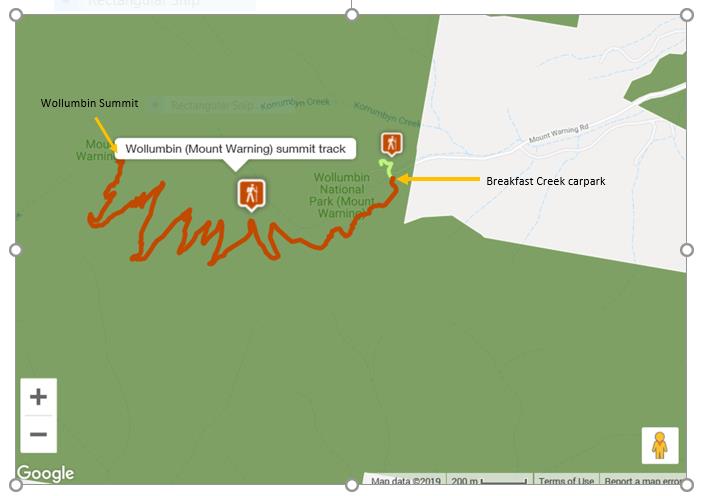 Figure 1 Wollumbin Summit Track
Track grading and condition
Figure 1 Wollumbin Summit Track
Track grading and condition
The
Australian Walking Track Grading System is used to grade walking tracks from a walker’s
comfort perspective. The higher the grade the harder the walk and/or the less services provided.
The Wollumbin Walking Track is graded as Grade 5 using the (AWTGS). The gradient in parts is
very steep, especially near the summit.
Australian Standards 2156.1 and 2156.2 are used to classify walking tracks and then set design,
inspection and maintenance standards. Under AS2156.1, the Wollumbin Summit Track is assigned
Class 3. Class 3 elements are:
•
Track conditions: Generally a modified track surface, sections may be hardened. Width variable
and less than 1200mm. Mostly clear of obstacles.
•
Gradient: May exceed 1:10 for short sections but generally no steeper than 1:10. Steps may be
common.
•
Signage: Signs and track markers may be used for direction. Limited signage for management
and interpretation purposes.
•
Infrastructure: Facilities generally not provided except for specific safety and environmental
considerations.
•
Terrain: Users need no bushwalking experience and a minimum level of specialised skills. Users
may encounter natural hazards (steep slopes, unstable surfaces, minor water crossings). Users
responsible for their own safety.
•
Weather: Storms may affect navigation and safety.
The track is largely a natural surface, with many steps. The final summit assent has a metal chain
section. There are bridges and stepping stones over watercourses and decking in some flatter
sections. At the summit, and at strategic viewpoints, there are viewing platforms with handrails.
The track is signposted with safety warning and interpretational signs.
Wollumbin Summit Track Risk Assessment – Confidential Final Report September 2019
2
Area staff advised that priorities for maintenance are based on safety, cultural and environmental
considerations.
Track Access
Access to the Wollumbin National Park is unrestricted with the exception of closures during heavy
rainfall, high winds or fire events. Following heavy rainfall, the access road is impassable. The local
council close the road with a gate.
Access is free and there are no booking system.
A proportion of walkers commence their assent in the night to reach the summit for dawn. Camping
within the park is not permitted (reference start of track warning sign), but it does occur.
There are no commercial operators approved to conduct guided walks within Wollumbin National
Park. The Wollumbin Consultative Group do not support tours to the summit.
4. CULTURAL & NATURAL HERITAGE VALUES
Wollumbin is a sacred place to the Bundjalung People and was declared an Aboriginal Place in
2015.
Wollumbin National Park’s subtropical rainforest forms part of the Gondwana world heritage-listed
rainforests of north-east NSW and south-east Queensland. This forest provides habitat for many
endangered and protected native species.
Wollumbin is the core of an extinct volcano. The surrounding ranges from the caldera. The summit
of Wollumbin is 1096m above sea level.
5. VISITATION AND TOURISM VALUES
The Wollumbin summit walk has been identified as one of the best day walks in Australia
(https://www.outdooraustralia.com/articles/18-of-the-best-day-walks-in-australia-04869) and is a
very popular walk with visitors to the NSW North Coast. The summit offers spectacular 360 degree
views over the caldera, rainforest, farms and out to sea.
The walk attracts an estimated 170 000 visits per year. Visitation to Wollumbin National Park, and
specifically the summit walk is a significant contributor to the local economy.
There are no Ecopass or other commercial tour operators on the mountain.
Visitor profile
Southern Cross University (SCU, 2018) undertook a survey of walkers at Wollumbin National Park
in April 2014. Their findings are provided in Tables 1-3 and summarised here:
• Visitors are predominantly young adults (61% of adult visitors aged 18-34).
• Overwhelming most visitors (92%) are from Australia, and most of these are from Queensland
(72%).
• Families with children made up 24% of groups. On the day of the survey the ratio was 20%
children, 80% adults.
Almost all visitors (95.3%) attempt to reach the summit, and most (87%) achieve it.
Individual safety appeared to be relatively minor consideration of walkers (refer to Table 3).
Interestingly only 2.1% of walkers did not progress beyond the bottom of the chain section (ie they
were deterred by the chains, steepness, safety signage or Aboriginal cultural sensitivity signage.)
Wollumbin Summit Track Risk Assessment – Confidential Final Report September 2019
3
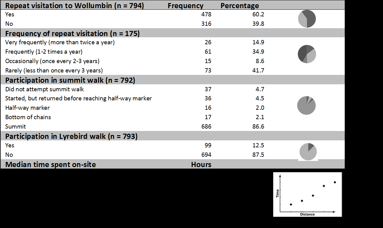
Most visitors (60%) are repeat visitors, with 49.8% those repeat visitors visiting at least annually.
These are not new visitors seeking a one-time iconic experience. Only 0.6% of identified climbing
Wollumbin as a ‘bucket list’ activity.
‘Reaching the summit’ was the most popular reason (at 33.7%) for visiting Wollumbin National Park.
Table 1 Wollumbin Summit Track Visitor Profile (SCU, 2018)
Table 2 Wollumbin Summit Track Visitor Experience (SCU, 2018)
Table 3 Reasons for Visiting Wollumbin National Park (SCU, 2018).
Wollumbin Summit Track Risk Assessment – Confidential Final Report September 2019
4
Reason
#
%
Summit
264
33.7
Physical activity / exercise / fitness
91
11.6
Visitors primarily
Hiking
79
10.1
come for the summit
Friends / family / colleagues
73
9.3
or experiences
Sunrise
66
8.4
associated with
View
38
4.9
climbing the
Nature / rainforest / beauty
38
4.9
mountain
Sightseeing / holiday
28
3.6
Adventure / challenge
22
2.8
Fun / enjoyment
11
1.4
Bucket list
5
0.6
Spiritual
5
0.6
Other (e.g. passing through; camping; team building)
63
8.0
Of the 4.7% of visitors who did not attempt the summit walk the reasons given were:
•
Not enough time / too late (15%)
•
Children (11%)
•
Health/physical ability (11%)
•
Respect for Aboriginal place (8.1%)
•
Others in group can’t/don’t want to (5.4%)
•
Not seeking a summit experience (5.4%)
•
Safety fears (2.7%)
•
Recognisance only (2.7%)
•
Unprepared (2.7%)
8.6% start the summit walk but don’t reach the summit. Reasons provided for this were:
•
Not enough time (1.9%)
•
Health/physical ability (1.8%)
•
Children (1.3%)
•
Safety fears (0.6%)
•
Respect for Aboriginal place (0.4%)
•
Others in group can’t/don’t want to (0.3%)
•
Not seeking a summit experience (0.1%)
•
Recognisance only (0.1%)
•
Done it before (0.1%)
Child hikers
On SCU’s survey day 20% of visitors were children. Parents with children represented 23.6%
groups surveyed.
During the risk assessment inspection (18 June 2019) family groups with children as young 8-10
years old were observed trekking the full distance to the summit. Some children running and
scrambling ahead of their parents or carers.
A review of social media on the Wollumbin Summit Track indicated that parents with babies on
backpacks had recently made the summit assent.
Wollumbin Summit Track Risk Assessment – Confidential Final Report September 2019
5
6. RECORDED INJURIES & FATALITIES
Area staff advised that most injuries reported to them ranged from minor slips and falls to broken
legs or ankles. This anecdotal evidence is supported by the 40 records of injuries or fatalities in
Tables 4 - 6 below, sourced from Area records, WSO and local media reports. In addition, the
injuries and fatalities, a further two walkers were lost and another two required rescuing due to bad
weather.
These records, although only a fraction of the actual number of visitor safety incidents occurring
provide a good insight into the range of serious incidents encountered on the Wollumbin summit
track. Minor injuries would be common and unreported. Data on fatalities or serious injuries is likely
to be more reliable as these incidents appear to be regularly covered in local media.
There were two recorded fatalities on the Wollumbin Summit Track in recent years (see Table 4).
Table 4 Recently Recorded Fatalities in Wollumbin National Park
Date
Incident details
Source
25/6/19
Fatality, 80yo woman, unconscious and could not be resuscitated,
WSO INC 107019261
1.5km into the walk.
6/12/16
Fatality, male, American tourist in his 20s killed when lighting struck
WSO INC107016498
at tree near the summit.
northernstar.com.au
Same incident resulting in
injury to his companion, an American
woman also in her 20s.
On 6 December 2016 the Northern Star newspaper published a
timeline of Wollumbin rescues
2010-2016 (see Table 5). Table 6 represents 2016-2019 data from emergency service records and
media reports.
Tables 5 and 6 demonstrates a continual and high response commitment by local emergency
services to walkers on Wollumbin coming into difficulty.
There is not enough detail to determine how many of these incidents occurred in the chain section.
However, the incident on 8/7/17 (see Table 6) did occur in the chain section, and it is likely that the
incidents on 8/9/14 (see Table 5), 18/8/19 and 20/7/18 (see Table 6) also occurred there.
If we combine records in Tables 5 and 6, seven of the recorded injured or ill were children, were 24
adults and the remaining 13 age information was not recorded. Events involving children represent
at least 16% of recorded injuries or fatalities. However, if we remove the five suspected heart, brain,
psychological or old age-related conditions, the three fatigued persons and the four persons lost or
stranded from the analysis, then injuries to children represented 19% of total injuries recorded. This
correlates positively with SCU’s (2018) field observations that 20% of walkers were children.
Accepting the small sample size of both the SCU’s field survey and these injury statistics, it may be
concluded that children are as likely as adults to experience injuries requiring emergency service
rescue.
The costs to emergency services (both government, charity-run or volunteer-run) in the region for
rescuing injured Wollumbin walkers are significant.
Wollumbin Summit Track Risk Assessment – Confidential Final Report September 2019
6
Table 5 Wollumbin National Park Rescues 2010-2016 (source: Northern Star newspaper).
Date
Incident details
Source
6/12/16
Fatality, male, American tourist in his 20s killed when lighting struck at tree
northernstar.com.au
near the summit.
Same incident resulting in
injury to his companion, an American woman also in
her 20s.
15/10/16 A 7yo girl suffered a
fractured arm and other injuries. She was walking on the
northernstar.com.au
track with her father, when another group of walkers approached. The girl
moved to the edge of the track and lost her footing, falling down an escarpment
about 10m high. Westpac Lifesaver 4 helicopter winched a doctor and
paramedic to treat her. The injured girl was winched from the scene and flown
to Gold Coast University Hospital for treatment.
9/10/16
A 41yo woman
broke her ankle halfway up the summit and needed to be
tweeddailynews.com.au
carried down, with the four-hour operation using two police cars, one
Ambulance, one SES crew and the Tweed District Rescue Squad.
Rescue squad deputy captain Rhett Murray said volunteers also had to help
another woman who
rolled her ankle up the mountain.
28/3/16
Local Afghanistan war hero was airlifted from the mountain after h
e suffered a
northernstar.com.au
PTSD-related panic attack.
21/9/15
A 42yo woman fell and sustained an
ankle injury.
tweeddailynews.com.au
20/6/15
A 27yo woman was evacuated by the Westpac Life Saver Rescue Helicopter
tweeddailynews.com.au
after a suspected
ankle fracture.
12/4/15
A woman in her 30s was stuck halfway up the track with an
injured ankle; and
tweeddailynews.com.au
an 11-year-old girl was
injured around the same spot.
30/11/14 A woman was
rescued by the Westpac Helicopter performing a winch recovery
northernstar.com.au
off Mt Warning.
8/9/14
A huge rescue operation involving 24 personnel took place on Mt Warning after
northernstar.com.au
a local woman in her 60s
injured her leg about 50 metres from the summit. Volunteers and ambulance personnel then embarked on a journey to reach the
women. Around this time, rescuers decided a medical team couldn't be winched
down by helicopter, due to heavy wind gusts and low visibility.
3/9/12
A 20yo Gold Coast woman was winched to safety by the Westpac Rescue
tweeddailynews.com.au
helicopter after the hiker hurt her
ankle while trying to descend from the top of
Mt Warning.
13/9/11
A 40-year-old man complained of
chest pains. A rescue helicopter was
tweeddailynews.com.au
dispatched but the man recovered and descended the mountain unaided by
rescuers.
8/11/10
A doctor and paramedic with the Westpac Life Saver Rescue Helicopter were
northernstar.com.au
winched down on to Mt Warning to treat an elderly man suffering
chest pains.
They were winched into the site after heavy cloud cover made it impossible for
the helicopter to land. Once stabilised the man was winched back into the
helicopter and transported to John Flynn Hospital on the Gold Coast.
30/7/10
A woman, 57yo, suffered a
serious hip injury after a fall while climbing Mount
tweeddailynews.com.au
Warning. Westpac Life Saver Rescue Helicopter has responded to the call. She
has been taken to hospital.
7/6/10
A 16yo girl suffered a suspected
leg injury after falling near the halfway mark
tweeddailynews.com.au
while climbing down the mountain. She had to be winched off Mount Warning
by helicopter.
25/4/10
A Gold Coast woman in her 50s, who
broke her leg climbing the mountain. She
northernstar.com.au
caught her foot in a tree root and fell awkwardly about 2.5kms up the popular
4.5km tourist trail and needed to be airlifted out.
Wollumbin Summit Track Risk Assessment – Confidential Final Report September 2019
7
Table 6 Wollumbin rescues 2016-2019 (source: Area records and
media reports).
Date
Time
Location
Incident
Injury
No. of
Gender
Age
Agency
Notes
People
18/08/20192
8:00
Summit
Injury
Possible
1
M
11
Westpac
Winched by
after fall
head
Rescue
Lifesaver
injuries,
Helicopter
Helicopter
stable
2/02/2019
18:16
Unknown
Injury
Unknown
1
F
35
SES
Winched by
Lifesaver
Helicopter
16/09/2018
18:18
1km from
Fatigue
Nil
1
M
Unknown
SES
Assisted walk
carpark
out
17/08/2018
12:50
0.4km
Injury
Ankle
1
F
61
SES
Patient carried
from
out
summit
12/08/2018
15:06
2km from
Injury
Unknown
1
Unknown
Unknown
SES
Patient carried
carpark
out
20/07/2018
15:07
Summit
Injury
Broken
1
F
12
SES / Police
Patient carried
leg
out in darkness
15/07/2018
13:52
2km from
Injury
Ankle
1
M
Unknown
SES / Police
Assisted walk
carpark
/ VRA
out
14/07/2018
8:03
Heli Point
Injury
Broken
1
M
17
SES
Winched by
4
Leg
Lifesaver
Helicopter
26/06/2018
14:04
Summit
Seizure
Nil
1
Unknown
14
SES
Winched by
Lifesaver
Helicopter
10/06/2018
12:11
Unknown
Lost
Nil
2
F
Unknown
SES / VRA
Wandered off
track
10/06/2018
16:25
2km from
Fatigue
Nil
1
F
Unknown
SES
Assisted walk
carpark
out
3/06/2018
11:19
1km from
Injury
Ankle
1
F
45
SES / Police
Patient carried
carpark
out
11/05/2018
16:34
Unknown
Injury
Unknown
1
M
Unknown
SES
Patient carried
out
3/02/2018
12:09
4km from
Injury
Broken
1
F
18
SES / Police
Patient carried
carpark
Leg
/ VRA
out
22/01/2018
10:43
Heli Point
Injury
Ankle
1
F
40
SES / Police
Winched by
3
Lifesaver
Helicopter
12/12/2017
16:44
Unknown
Lost
Nil
1
M
25
SES
Wandered off
track
5/10/2017
5:20
1km from
Injury
Ankle
1
F
Unknown
SES
Patient carry
carpark
out to
Ambulance at
carpark
9/08/2017
6:24
Summit
Fatigue
Nil
1
M
Unknown
SES / Police
Winched by
Lifesaver
Helicopter
31/07/2017
10:01
Unknown
Injury
Minor Leg
1
F
Unknown
SES
Patient carry
Injury
out
11/07/2017
14:53
Unknown
Injury
Ankle
1
F
22
SES/Police/
Winched by
VRA
Lifesaver
Helicopter
8/07/20171
Chain
Injury
Face &
1
F
47
Westpac
Winched by
section,
shoulder
Rescue
Lifesaver
Summit
stable
Helicopter /
Helicopter
Ambulance
20/01/2017
23:05
Summit
Weather
Nil
2
Unknown
Unknown
SES / Police
Assisted return
/ VRA
from summit
due to wet
weather
1/01/2017
8:58
Unknown
Injury
Ankle
1
F
Unknown
SES / VRA
Transferred to
Ambulance at
carpark
6/12/2016
4:50
Summit
Death /
Lightning
2
M & F
Unknown
SES / Police
Were camping
Injury
strike
/ VRA
on summit
overnight
28/03/2016
18:30
Summit
Fatigue
Nil
1
M
Unknown
SES / VRA
Winched by
Lifesaver
Helicopter
Shading = record of incident common to in tables 4-6.
1 Source: Echo NetDaily – 10/7/2017
2 Source: Echo NetDaily – 19/8/2019 and nbnnews.com.au 18/8/19.
Wollumbin Summit Track Risk Assessment – Confidential Final Report September 2019
8
7. LEGAL AND POLICY CONSIDERATIONS
Civil Liability Act 2002
Under common law is that NPWS owes a duty of care to take care of the safety of those who enter
on land that it manages. Under the
Civil Liability Act 2002, NPWS is not negligent in failing to take
precautions against a risk of harm unless:
1.
the risk was foreseeable (that is, it is a risk of which NPWS knew of, or ought to have known)
2.
the risk was not insignificant
3.
in the circumstances, a reasonable person in the NPWS’s position would have taken
additional precautions to limit or remove the risk (S5B).
When determining what precautions, a reasonable person in NPWS’s position would take in the
circumstances, the
Civil Liability Act provides guidance. Section 5B (2) provides that when
determining whether a reasonable person would have taken certain precautions, you should
consider:
(a)
the probability of the harm occurring
(b)
the likely seriousness of the harm
(c)
the burden of taking the precautions
(d)
the social utility of the activity that creates the risk of harm.
NPWS does not owe a duty for recreational activities where it has given warnings about the risks
involved. Section 5M (1) of the
Civil Liability Act provides that ‘
a person does not owe a duty of care
to another person (the plaintiff) who engages in a recreational activity to take care in respect of a
risk of the activity if the risk was the subject of a risk warning’.
Section 5K describes 'recreational activity' to include:
‘
(a) any sport (whether or not the sport is an organised activity), and
(b) any pursuit or activity engaged in for enjoyment, relaxation or leisure, and
(c) any pursuit or activity engaged in at a place (such as a beach, park or other public open space)
where people ordinarily engage in sport or in any pursuit or activity for enjoyment, relaxation or
leisure.’
In order to receive the benefit of this protection from liability for injuries arising out of recreational
activities, the following must be observed:
•
Risk warnings must be given in a manner that is reasonably likely to result in people
being warned of the risk before engaging in the recreational activity. It is not necessary to
show that a particular person actually received or understood the risk warning (S5M (3)).
•
Risk warnings may be given orally or in writing (S5M (4)). Risk warnings can be given by
way of warning signs. They may also be given in brochures, park website, maps and entry
passes, etc. (as long as the person is reasonably likely to be warned of the risk in this way).
Also, when NPWS staff are in the park they can give oral warnings to anyone they observe
on the track or approaching the track.
•
Risk warnings must be given by or on behalf of NPWS (ie NPWS cannot rely on risk
warnings given by other persons) (S5M (6)). It is recommended that the NPWS logo be
included on any signs or written materials handed out which warn of a risk.
Also note that NPWS cannot rely on a risk warning for protection from liability for negligence if:
Wollumbin Summit Track Risk Assessment – Confidential Final Report September 2019
9
•
NPWS has failed to comply with any New South Wales or Commonwealth laws providing
specific practices or procedures for the protection of personal safety (S5M (7))
•
A risk warning has been contradicted by an oral or written representation as to risk made by
or on behalf of the NPWS to the injured person (S5M (8)).
•
The person who suffers harm is an 'incapable person' (i.e. a child or person suffering from a
physical or mental disability), except if they are under the control of or accompanied by a
capable adult who has been warned of the risk, or if a parent (whether accompanying the
child or not) has received the risk warning (S5M (2)).
In addition, park visitors
may sometimes be unaccompanied incapable persons (ie children or
persons with a physical or mental disability, who lack the capacity to understand risk warnings. It
may be interpreted that in these cases, that warning signs may not always be sufficient to protect
NPWS from liability.
The
Civil Liability Act states that a land manager will not be liable for harm resulting from an
obvious risk of a
dangerous recreational activity (S5L). A ‘dangerous recreational activity’ is
defined as a recreational activity that involves a significant risk of physical harm (S5K). However,
where a risk of a dangerous recreational activity is not obvious (as understood above), NPWS may
still be liable.
National Parks and Wildlife Regulation 2019
Unde
r National Parks and Wildlife Regulation 2019 (C25) a person must obtain consent for any
activity or recreational pursuit that involves risking the safety of that person or other people. Clause
25 (2) contains a non-exhaustive list of risky recreational activities for which the consent of the park
authority is required, unless they are provided for in a plan of management. These risky activities
currently include caving, abseiling, base jumping, bungy jumping, rock climbing, parachuting,
canyoning, whitewater, boating, paragliding, parasailing and hang gliding. Bushwalking is not
ordinarily deemed a risky recreational activity.
Work Health & Safety Act 2011
Civil liability obligations often overlap with work health and safety (WHS) obligations. The main
statute dealing with WHS in New South Wales is the
Work Health and Safety Act 2011 (WHS Act).
Under the WHS Act, the NPWS has obligations to:
•
Ensure the health, safety and welfare of employees.
•
Ensure the health, safety and welfare of persons other than employees at a place of work
(e.g. members of the public who are on park).
Enterprise Risk Management Policy and Procedures
The
OEH Enterprise Risk Management Policy (OEH, 2018) outlines OEH’s approach to enterprise
risk management and prescribes a minimum set of risk management standards for all business
areas across the agency. In adopting this systematic management of risk, OEH seeks to control
unacceptable risk while at the same time continuing to identify opportunities, foster creativity and
innovation to encourage learning and improvement and support the achievement of objectives.
OEH’s relevant risk appetite statements are:
•
OEH encourages activities that maximise opportunities through change and innovation,
and identifies activities where it is important to avoid or minimise risks.
•
OEH has zero tolerance for lack of effective WHS management systems.
Wollumbin Summit Track Risk Assessment – Confidential Final Report September 2019
10
•
OEH has a high appetite for compliance with relevant legislation, regulation, industry codes,
standards, internal policies and sound corporate governance principles.
•
OEH has a high appetite for opportunities to improve our customer, stakeholder and staff
engagement and safety.
•
OEH has a high appetite for opportunities to demonstrate innovation and leadership in
environmental and heritage conservation and national park management.
The policy is supported by the
OEH Enterprise Risk Management Procedures (OEH, 2019), which
detail the steps to followed when undertaking a risk assessment and provide tools to inform the
assessment.
Visitor Safety Policy
NPWS’ Visitor Safety Policy and Procedures provides a framework for managing visitor safety risk
within NSW national parks. It builds around NPWS’ obligations arising from the
Civil Liability Act,
National Parks & Wildlife Regulation, Work Health & Safety Act and the agency’s risk enterprise
management procedures.
The Policy states that:
•
Visitor safety risks are to be assessed using the Health & Safety Risk Matrix.
•
Management responses to visitor safety hazards should consider the setting, ease of access
and levels of visitation.
•
More significant risks should be given higher priority for resources than less-significant risks.
•
NSW Police has statutory responsibility for all search and rescue operations. NPWS will
provide assistance to search and rescue operations as appropriate.
Tree Risk Management Policy
NPWS’ Tree Risk Management Policy (NPWS’ 2013) and procedures provide guidance to staff on
managing hazardous trees within NSW national parks. It documents a systematic approach to tree
risk management from identifying hazardous trees, through assessment, treatment and finally
documenting the hazard, its risk rating and its treatment in NPWS’ systems – WSO and AMS.
Appendix B of the procedures contains a tree hazard checklist for field staff to use.
Note that NPWS has not adopted a quantified state-wide tolerability level for tree risk. Nor a
statewide requirement on inspection frequency. But in determining a local inspection schedule
NPWS should consider inspection prior to peak visitation times and after severe environmental
conditions (eg fire, prolonged rainfall, high winds, intense lightning activity, flooding and rain after
prolonged dry periods.)
Wollumbin Summit Track Risk Assessment – Confidential Final Report September 2019
11
8. HAZARD IDENTIFICATION & RISK ASSESSMENT
Principles
This risk assessment is guided by the OEH Risk Management Policy principles:
•
Priority will always be given to the protection of life and property, consistent as far as
possible with the protection of environmental values, both natural and cultural.
•
Risks will be treated in accordance with their rating, with risks rated as extreme being
addressed first, followed, as resources permit, by those rated high, then medium and lastly
low.
Hazard identification
Site and visitor behaviour hazards (listed in Table 7) were identified through a site visit on 18 June
2019 and review of WSO reports, media reports, incident data and visitation data
This initial hazard identification was further refined to a list of 11 visitor safety risks for the
Wollumbin Summit Track:
All sections:
1.
Hazardous trees or branches falling on walker(s) causing serious injury or fatality.
2.
Rock fall, landslide or slope instability along the track causing serious injury or fatality to
walker(s).
3.
Slips, trips or falls due to rough surfaces, exposed roots, creek crossings, wet ground etc.
causing serious injury or fatality to walker(s).
4.
Walker(s) leaving the track and becoming lost leading to serious injury.
5.
Lack of walker skill, experience or health condition leading to serious injury, illness or fatality.
6.
Walker(s) exposed to extreme weather (heat, cold, heavy rainfall and thunderstorms)
conditions resulting in serious illness (ie heat stroke/exhaustion, dehydration or hypothermia)
or serious injury (lightning strike).
7.
Walker(s) bitten or stung by snakes, spiders, ticks or insects resulting in illness or fatality.
8.
Delays in emergency response to lost or injured walker(s) endangering patient survival.
9.
Built asset (elevated platforms, handrails, constructed pathway) failure causing serious injury
or fatality to walker(s).
Chain section only:
10.
Failure of the chain and anchor system causing serious injury or fatality to walker(s).
11.
Slips, trips or falls ascending and descending the chain section causing serious injury or
fatality to walker(s).
A summary of the risk assessment is provided in Table 8. Detailed analysis of each risk is provided
in Section 9, as well as, treatment plan recommendations.
Wollumbin Summit Track Risk Assessment – Confidential Final Report September 2019
12
Table 7 Wollumbin Summit Track Hazard Identification
Site hazards
Length of walk
X 4-6hrs
Steepness of walk
X
No/restricted drinking water
X water only at carpark
Steps
X
Chain/rope sections
X
No constructed shelter
X
Ladders
Unfenced cliffs/slopes
X
No/restricted toilet facilities
X toilets only at carpark
Elevated platforms
X
Treefall
X
No/limited mobile phone coverage
X on track but not at carpark
Roads/vehicles
Rockfall/landslide
X
Poor condition of track
X
Remote access
X
Hostile neighbours
Poor condition of park infrastructure
X
Wet weather/storms
X
Creek crossings
X
Fire
X
Cold weather
X
Wet ground
X
Snow/ice
Hot weather
X
Rocky ground
X
Flood/rivers
X
Coast/waves/tide
Snakes
X
Ticks/leeches/insects
X
Visitor behaviour hazards
Overcrowding
X 170K pa
Theft
X
Selfies
X but handrails at summit
Lack of parking
X
Unfit for walk
X
Ill-prepared (lack of water, clothing, skills)
X
Partying/drinking/drug taking
Cycling/mountain
Travelling with children
X babies & children of all ages
biking
Foolish behaviour/skylarking
X
Boating/kayaking
Swimming/surfing
X swimming in creek
Bushwalking
X
Fishing
Camping overnight
X dawn summiteers
Events (rogaining, fun runs)
X
Horse riding
Night walking
X dawn summiteers
Events (concerts, fireworks)
4WD driving
Rock climbing/abseiling/canyoning
X but not near summit track
Trail running, exercising
X
Drones
Skiing/snowboarding
Table 8 Visitor Safety Risk Assessment for Wollumbin Summit Track
Risk Risk Event
Source
Consequences
Consequence Likelihood
Risk Rating
Existing Controls
Existing
Control
Potential
Id
Rating
Rating
Control Type3
Effectiveness4
Exposure5
1
Hazardous trees or
Hazardous trees
Serious injury or fatality.
Major (fatality)
Unlikely
Medium
Hazardous tree inspections and
Elimination &
Medium-High
Major
branches falling on
removal of hazardous trees or limbs.
Administration
High wind conditions
Loss of reputation and
walker(s) causing serious
trust.
Regular track inspections and
injury or fatality.
Fire events
maintenance.
Geological instability
Moderate (long
Possible
Medium
Park closure during heavy rainfall,
term impairment)
high winds or fire events.
Specific safety messaging on website
attraction page to avoid visiting in
high winds.
Staff respond to hazard reports from
the public.
Staff training in hazardous tree
identification.
2
Rock fall, landslide or
Rock fall, landslide or slope
Serious injury or fatality.
Catastrophic
Rare - at
Medium
Slope stability assessment (GHD,
Isolation &
Medium-High
Catastrophic
slope instability along the
instability
(multiple
helipads & base
2018).
Administrative
Loss of reputation and
track causing serious
fatalities) - at
of chain section
trust.
Specific rockfall safety signage.
injury or fatality to
emergency
walker(s).
helicopter points
Regular track inspections by field
& base of chain
officers.
section
Park closure during heavy rainfall,
Major (fatality)
Rare
Medium
high winds or fire events.
3
Slips, trips or falls.
Uneven surfaces, exposed
Serious injury or fatality.
Major (fatality)
Unlikely
Medium
General safety and specific walking in
Engineering,
Medium
Major
causing serious injury or
roots, creek crossings, wet
darkness signage.
Administrative &
Loss of reputation and
fatality to walker(s).
ground
PPE
trust.
Regular inspections by field officers.
Minor (broken
Likely
Medium
Walking in darkness or
leg/ankle)
Park closure during heavy rainfall,
poor weather
high winds or fire events.
4
Walker(s) leaving the track
Visitor behaviour
Serious injury or illness.
Moderate (night
Possible
Medium
General, specific ‘stay on track’ and
Administrative
Low
Major
and becoming lost leading
walking)
half-way safety signage.
Walking in darkness or
Loss of reputation and
to serious injury or illness.
poor weather
trust.
Distance and location information at
Minor
Possible
Low
emergency helicopter points.
Marked track.
Mobile phone coverage most of track.
5
Lack of walker skill,
Walker lack of skill,
Serious injury or fatality.
Major (fatality)
Possible
High
General safety, half-way warning and
Administrative
Low
Major
experience or health
experience or health
chain section signage.
condition (eg heart attack)
condition (eg heart attack).
Specific messaging warning of the
leading to serious injury,
Minor (broken
Probable
Medium
strenuous climb on attraction website.
illness or fatality.
leg/ankle)
Well-marked track.
6
Walker(s) exposed to
Rapidly changing weather
Serious illness, injury or
Major (fatality)
Unlikely
Medium
General safety and thunderstorm
Isolation,
Medium
Major
extreme weather (heat,
conditions
fatality.
warning signage.
Administrative &
cold, heavy rainfall and
PPE
High rainfall area
Specific messaging on attraction
thunderstorms) conditions
Minor (temporary
Possible
Low
website.
resulting in serious injury
Under-prepared walkers
illness)
or fatality (ie heat stroke or
Park closure during high rainfall, high
exhaustion, dehydration,
wind or total fire ban days.
hypothermia or lightning
strike).
7
Walker(s) bitten or stung
Snakes, spiders, ticks or
Serious illness or fatality.
Major (fatality)
Unlikely
Medium
General safety signage.
Administrative &
Low
Major
by snakes, spiders, ticks
insects
PPE
Well-marked track.
or insects resulting in
Insignificant
illness or fatality.
Likely
Low
Specific information on attraction
(temporary
page on website to bring a first aid kit.
illness)
Risk Risk Event
Source
Consequences
Consequence Likelihood
Risk Rating
Existing Controls
Existing
Control
Potential
Id
Rating
Rating
Control Type3
Effectiveness4
Exposure5
8
Delays in emergency
Poor weather restricting
Serious injury or fatality.
Major (fatality)
Rare
Medium
Mobile phone coverage most of track.
Engineering &
Medium
Catastrophic
response to lost or injured
helicopter access
Administrative
Loss of reputation and
Safety and locational signage.
walker(s) endangering
Terrain and closed forest
trust.
patient survival.
4 helicopter winch points and helipad
Mobile phone blackspots
at summit.
Disruptions to normal
Emergency service personnel
mobile coverage
regularly deployed on Wollumbin
rescues (experienced).
Relatively close proximity to
emergency services and hospitals.
VRA for ground-based rescues.
High visitation levels.
9
Built asset (elevated
Poor design
Serious injury or fatality.
Catastrophic
Rare
Medium
5-yearly engineering inspections of
Engineering &
Medium
Catastrophic
platforms, handrails,
(multiple
elevated platforms.
Administrative
(Extreme)
Insufficient maintenance
Loss of reputation and
constructed pathway)
fatalities)
trust.
Regular 6-monthly inspection and
failure causing serious
Overuse
maintenance by field staff.
injury or fatality to
Major (fatality)
walker(s).
Vandalism
Unlikely
Medium
Staff respond to visitor reports of
asset damage.
Minor (broken
Possible
Low
leg/ankle)
10
Failure of the chain and
Poor design
Serious injury or fatality.
Catastrophic
Rare1
Medium2
Regular inspection and maintenance
Engineering &
Medium
Catastrophic
anchor system causing
(multiple
by field staff.
Administrative
(Extreme)
Insufficient maintenance
Loss of reputation and
serious injury or fatality to
fatalities)
trust.
walker(s).
Overcrowding - too many
walkers on the chain
Temporary or permanent
Major (fatality)
Unlikely
Medium
section
closure of the track.
Overuse
Minor (broken
Possible
Medium
Vandalism
leg/ankle)
11
Slips, trips or falls
Overcrowding - too many
Serious injury or fatality.
Catastrophic
Rare
Medium
The chain and anchor system.
Engineering,
Medium
Catastrophic
ascending and descending
walkers on the chain
(multiple
Administrative &
(Extreme)
Loss of reputation and
the chain section causing
section
fatalities)
PPE
trust.
serious injury or fatality to
Poor visitor behaviour
walker(s).
Major (fatality)
Possible
High
Specific safety signage at the chain
section.
Poor design
Minor (broken
High
Insufficient maintenance
Probable
leg/ankle)
Park closure during high rainfall
events.
Notes:
1 & 2 Using the risk matrix in
Quick Reference Guide – Asset Performance Assessments – Walking tracks and elevated structures (Table 2 assessment of risk and barrier location) yielded 1 (Likely) and 2 (Extreme). However, given that there are no recorded incidents
of this magnitude, we have used the OEH Health & Safety Risk Matrix ratings.
3 & 4 Control Type3 and control effectiveness4 are rated as per the
OEH Health & Safety Risk Matrix (see Appendix 1).
5 Potential exposure is the highest (worst case) consequence that could occur if all existing controls failed.
Constraints and acknowledgments:
1.
This report considers risk to visitor safety but these risks may also apply to staff working on or using the track. No consideration of specific tasks undertaken by staff maintaining the track has been undertaken, but it is fair to deduce that working rather than just
walking the track could increase risks to staff safety.
2. This report does not look at risks to emergency services in undertaking helicopter or land-based searches, rescues or recoveries.
3. The author acknowledges that local Aboriginal community are opposed to walkers accessing the mountain above the 600m mark, the installation of new assets or modification to the natural environment. This assessment is respectful of these views, but it focussed
primarily on assessing and protecting visitor safety.
Wollumbin Summit Track Risk Assessment – Confidential Final Report September 2019
15
9. DETAILED RISK ASSESSMENTS
Risk 1. Hazardous trees or branches falling on walker(s) causing serious injury or fatality.
Risk Risk Event
Source
Consequences
Consequence
Likelihood
Risk
Existing Controls
Control
Control
Potential
Id
Rating
Rating
Rating
Type
Effectiveness Exposure
1
Hazardous trees or
Hazardous trees
Serious injury or fatality.
Major (fatality)
Unlikely
Medium
Hazardous tree inspections and removal of
Elimination &
Medium - high
Major
branches falling on
hazardous trees or limbs.
Administration
High wind conditions
Loss of reputation and
walker(s) causing
trust.
Track inspections and maintenance.
serious injury or fatality.
Fire events
Park closure during heavy rainfall, strong winds
Geological instability
Moderate (long term
Possible
Medium
or fire events.
impairment)
Specific safety messaging on website attraction
page to avoid visiting in high winds.
Staff respond to hazard reports from the public.
Staff training in hazardous tree identification.
Discussion
The risk of a fatality or a serious injury from tree fall are both considered to be medium. There is also a risk of walkers suffering minor injuries, such as striking their head on low branches and eye stick injuries.
Most of the track is within closed forest. The forest is a dynamic environment with trees or limbs falling regularly. The risk of tree fall is increased in the few exposed sections (the summit) or where walkers stop and
linger (emergency helicopter points); or immediately following rain, or during strong winds; or following a fire. Geological instability may also increase the risk of tree fall. Access to the summit track is restricted during, or
immediately following heavy rainfall events due to the flooding of the access road. This reduces the overall risk to walkers by reducing the walker numbers on the mountain, but does not reduce the risk to individual
walkers already on the mountain when the wet or windy weather starts.
Fallen trees may present a hazard if blocking the track and causing visitors to negotiate a barrier at a dangerous location. Falling trees may also cause damage to track infrastructure and delay rescue operations.
Through the Tree Management Policy and procedures NPWS has not set a statewide requirement on hazardous tree inspection frequency. But given the high volume of walkers and high rainfall experienced at least a
six-monthly inspection regime is reasonable. (Consistent with regime for geological instability hazards recommended by GHD, 2018). Inspections should be scheduled for immediately prior to peak visitation periods (ie
new year, holiday periods). These inspections should be supplemented with inspections post severe environmental conditions (eg fire, high or prolonged rainfall (150+mm in 24hrs), high winds, intense lightning activity,
flooding and rain after prolonged dry periods.) Inspections must include both tree hazard and tree management infrastructure, such as barrier fencing and signs in the park and alerts or messaging on the national park
website.
Area staff advise that they are aware of the Tree Risk Policy and use it to identify hazardous trees. Inspections are logged in AMS. Tree inspections are undertaken quarterly or following heavy rainfall or storms. Also
covered in monthly general inspections. An AMS report for 2014-19 records that removals of fallen trees is regularly recorded (examples on 5/3/19, 9/1/19 and 2/9/19), but hazardous tree inspections are rarely recorded
(one record on 12/10/16), or are recorded without sufficient detail to identify these events in AMS.
Reports of hazardous trees and fallen trees from staff and the public are recorded in AMS.
Area staff advise that they are training in hazardous tree assessment but require more training.
The Area have developed a
Visitor Access Management Plan (Tweed-Byron Area, 2019) for the Wollumbin Summit Track that specifies these controls to reduce risks to visitor safety in heavy rainfall or strong winds:
1. Weather conditions monitored in BOM Meteye by Park Ranger or designated Officer
2. The park will be closed when:
• Predicted high rainfall events: forecast rainfall is greater than 80mm in one event AND / OR
• Predicted high wind event: forecast wind is greater than 70km/hr
3. The day before either of these forecast conditions:
• NPWS officers will check both Summit Walking Track and Lyrebird Walking Track to ensure all visitors have left the Park (wearing helmets and other appropriate PPE)
• Park Closed signs installed on tourist sign at intersection Mt Warning and Kyogle Rd and entrance to Park at carpark. Hazard tape placed across start of Summit Walking Track. Photographs to be taken of
signs and uploaded into AMS.
• Council gate closed – with permission from Tweed Shire Council.
• Park neighbours notified, Elements updated and Local Tourist Information Centres informed.
In addition: Numerous creek crossings on the Mt Warning Rd are liable to flooding and closure during rainfall events. These will assist preventing visitor access to the Park.
Field observations
Park management appeared to be generally consistent with NPWS’ Tree Risk Management Policy and Procedures (NPWS, 2013.)
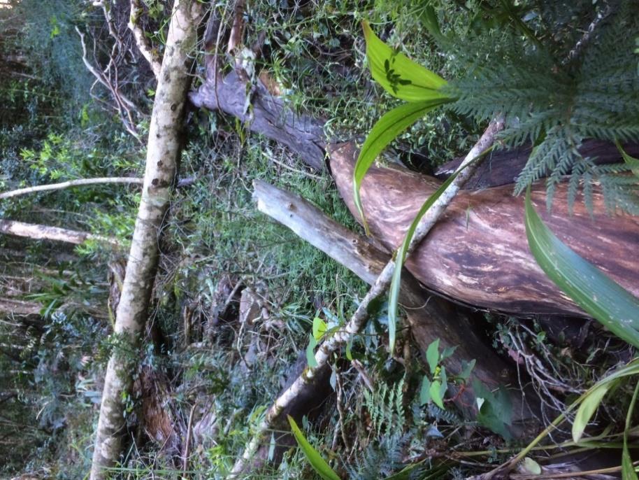
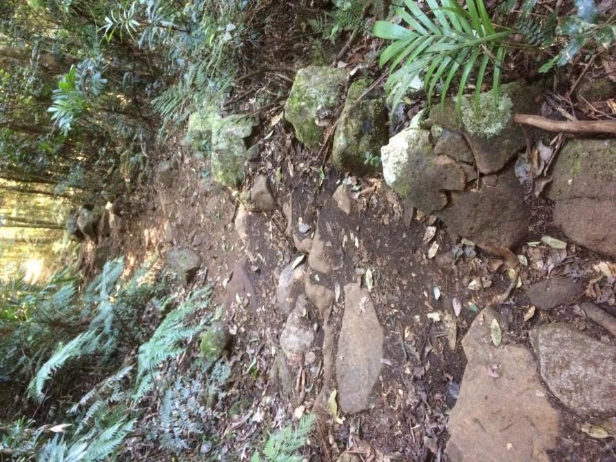
On the risk assessment inspection evidence of recent tree falls were sighted (Refer to Figure 2).
There were no specific warnings about tree hazard on website or on park signs. But there is a warning sign informing walkers not to proceed to the summit during thunderstorms.
Recommended treatment plan actions
1. Continue to implement NPWS Tree Risk Policy and Procedures to identify, assess, manage, report, record and inspect hazardous trees.
2. Add a specific warning about walking in Wollumbin National Park during high winds on park signs and national park website.
3. Log hazardous trees (or groups of hazardous trees) in WSO and use WSO to record their hazard assessment and risk treatment plan. Log cyclic inspections and
works arising from the treatment plan in AMS.
4. Train staff in tree hazard assessment. (Note: the need to provide more specialised tree assessment training for field staff is being considered in the redrafting of the
Tree Risk Policy and Procedures.)
The effectiveness of these controls, when combined with existing controls, is assessed to be medium to high. The residual risk rating on completion of the Risk Treatment
Plan is assessed as medium.
Consequence Rating
Likelihood Rating
Residual Risk Rating
Major (fatality)
Rare
Medium
Moderate (long term impairment)
Unlikely
Medium
Figure 2 Recent tree fall on the Summit Track.
Wollumbin Summit Track Risk Assessment – Confidential Final Report September 2019
17
Risk 2 Rock fall, landslide, cliff or slope instability along the track causing serious injury or fatality to walker(s).
Risk
Risk Event
Source
Consequences
Consequence Likelihood
Risk Rating
Existing Controls
Control
Control
Potential
Id
Rating
Rating
Type
Effectiveness
Exposure
2
Rock fall, landslide or
Rock fall, landslide or
Serious injury or fatality.
Catastrophic
Rare - at
Medium
Slope stability assessment (GHD,
Isolation &
Medium-High
Catastrophic
slope instability along
slope instability
(multiple
helipads & base
2018).
Administrative
Loss of reputation and trust.
the track causing
fatalities) - at
of chain section
Specific rockfall safety signage.
serious injury or fatality
emergency
to walker(s).
helicopter points
Regular track inspections by field
& base of chain
officers.
section
Park closure during high rainfall events.
Major (fatality)
Rare
Medium
Discussion
Wollumbin is the core of the Tweed shield volcano, last active 23 million years ago. It is a volcanic landscape with steep slopes, dense rainforest vegetation and high rainfall. Rainfall events, tree fall or track overuse
may cause the rapid or gradual rock fall or landslip events. On steep slopes, soils are usually shallow and run-off exceeds infiltration (GHD, 2018).
GHD (2018) undertook a slope stability assessment of the Wollumbin Summit Track for NPWS. GHD identified 22 hazards near the track described as rock topple, translational debris slide, translational debris creep and
rock dislodgement by water. The GHD (2018) report should be read in full to meaningfully consider the geological hazards present.
GHD (2018) also indicated inferred hazards, where evidence of past failures may infer likely hazards and their locations. GHD mapped three zones: Zone 1: Rockfalls and slides (closer to the summit), Zone 2:
Translational debris slides (mid slope), and Zone 3: Rotational debris slides and flows (mid to lower slope). Heavy rain is the common trigger for all these geological events.
GHD (2018) assessed the total estimated annual risk (preliminary) to be 12. x 10-7 annual probability of individual being killed (or 1.9 fatalities per 100 years), which is low based on the GeoGuide LR7. This low
assessed risk is based on the lower likelihood of an individual being at the wrong place at the wrong time, which is likely to be the case because access to the track following heavy rainfall is restricted by the closure of
the Mt Warning Rd, as well as, most walkers’ preference to avoid trekking in poor weather.
There are no records of fatalities or injuries from a rockfall or landslide.
To mitigate the risks and develop a more detailed quantitative risk assessment, GHD (2018) in summary proposed:
1. Managing track access in response to forecast heavy rainfall (eg (a) pre-emptive gate closing, (b) monitoring access by staff or surveillance cameras and signs).
2. Scaling of loose trackside boulders.
3. Track inspections at least six-monthly and following rainfall event of 150mm in 24 hours.
4. Maintain a register of descaling works and new hazards.
5. Mitigate harm to walkers already on the mountain when heavy rainfall occurs by providing (a) a walker registration system and (b) refuge shelters in safer areas.
6. Undertake further investigation to support a quantitative risk assessment including (a) Review of hazards and their detachment and travel probabilities with reference to frequency of trigger weather events; (b)
Review of temporary spatial probability using daily patronage data and comparing this to rainfall records; and (c) Development of a risk profile for different weather conditions to assist in deciding when to close
the track and how strictly to enforce the closure.
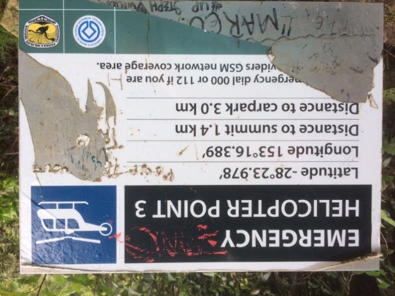
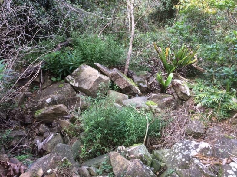
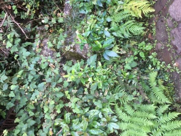
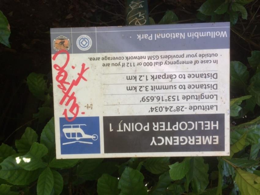
Of most concern to the Area is hazard H16 – a translational debris slide, located immediately above Emergency Helicopter Point 3. H16 is described as rapid speed but small-scale hazard. Refer to Figures 3-5.
Due to the dense canopy there are few viewing points along the track on the way to the summit. The Emergency Helicopter Points provide these vantage points and are popularly-used by walkers as rest and vantage
points. Hence, the risk of a geological event injuring or killing a walker at these gathering points is higher than in other sections of track where walkers are only momentarily in one space and they would be passing
single/double file.
The risk rating for gathering points (eg Emergency Helicopter Point 3) is assessed to be medium. The risk rating for the remainder of the track is also medium.
Field observation
Rocks of approximately 150mm in diameter are evidence of a previous rockfall event immediately upslope of the Emergency Helicopter Point 3. Refer to Figures 3 and 5.
During the site inspection on 18/6/19 several individuals (at least 3 groups) were taking a rest/drink break at Emergency Helicopter Point 3.
Wollumbin Summit Track Risk Assessment – Confidential Final Report September 2019
18


Area staff advise that the park access gate is proactively closed when heavy
rainfall events are forecast, which accords with recommendation 1 listed
above.
Area staff advice and AMS records confirm that track inspections are
occurring on a 6-monthly basis or post heavy rainfall events, which meets
recommendation 3 above.
The online NPWS bushwalker trip intention form, launched on 30 August
2019, will meet recommendation 5(a).
However, some of the other treatment plan actions proposed by GHD (2018)
do not appear to have been implemented by the Area.
Figure 5 Rocks from
Figure 3 H16 translational debris slide above
Figure 4 Emergency Helicopter Point 3
former slide beside the
the track at Emergency Helicopter Point 3.
information sign.
track at Emergency
Helicopter Point 3.
Recommended treatment plan actions
Implement GHD’s (2018) outstanding recommendations by:
1. Managing track access in response to forecast heavy rainfall (eg monitoring access by staff or surveillance cameras and signs).
2. Undertake further investigation to support a quantitative risk assessment including (a) Review of hazards and their detachment and travel probabilities with reference to frequency of trigger weather events; (b)
Review of temporary spatial probability using daily patronage data and comparing this to rainfall records; and (c) Development of a risk profile for different weather conditions to assist in deciding when to close the
track and how strictly to enforce the closure.
3. Scaling of loose trackside boulders. Priority to be given to hazards impacting gathering points such as Emergency Helicopter Point 3.
Note: scaling works are not supported on cultural heritage grounds, alternatives
may be considered including installation of barriers to halt or divert rock movement away from gathering spots, or barriers and signs to warn walkers against stopping at higher risk locations. For the latter to be
effective, new resting and viewing spots will need to be created at lower risk locations.
4. Maintain a register of descaling works
(in AMS) and new hazards
(in WSO).
5. Mitigate harm to, or facilitate rescue for, walkers already on the mountain during heavy rainfall events by providing refuge shelters in safer areas.
The effectiveness of these controls, when combined with existing controls, is assessed to be medium to high. The residual risk rating on completion of the Risk Treatment Plan is assessed as medium.
Consequence Rating
Likelihood Rating
Residual Risk Rating
Catastrophic (multiple fatalities) - at emergency helicopter points & base of chain section
Rare - at helipads & base of chain section
Medium
Major (fatality)
Rare
Medium
Wollumbin Summit Track Risk Assessment – Confidential Final Report September 2019
19
 Risk 3 Slips, trips or falls due to rough surfaces, exposed roots, creek crossings, wet ground etc. causing serious injury or fatality to walker(s).
Risk
Risk Event
Source
Consequences
Consequence
Likelihood Risk Rating
Existing Controls
Control Type Control
Potential
Id
Rating
Rating
Effectiveness Exposure
Risk 3 Slips, trips or falls due to rough surfaces, exposed roots, creek crossings, wet ground etc. causing serious injury or fatality to walker(s).
Risk
Risk Event
Source
Consequences
Consequence
Likelihood Risk Rating
Existing Controls
Control Type Control
Potential
Id
Rating
Rating
Effectiveness Exposure
3
Slips, trips or falls causing
Uneven surfaces,
Serious injury or fatality.
Major (fatality)
Unlikely
Medium
General safety signage.
Engineering,
Medium
Major
serious injury or fatality to
exposed roots, creek
Administrative &
Loss of reputation and
Regular inspections by field officers.
walker(s).
crossings, wet ground
PPE
trust.
Minor (broken
Likely
Medium
Park closure during storm or high
Walking in darkness or
leg/ankle)
rainfall events.
poor weather
Discussion
Minor injuries (cuts, abrasions, sprains, strains, and/or broken bones) as a result of slipping or tripping on rocks, exposed tree roots and/or unstable ground have been recorded. Creek crossings, wet areas along the
track and during rainfall increase the likelihood of falls. The likelihood of tripping or slipping is increased in wet weather, darkness or with fatigue. Whilst all falls have the potential to be fatal, this risk is increased for
sections of track within 2m of the slope edge/ cliff. This includes vantage points at Emergency Helicopter Points or other informal lookouts. This risk is assessed as medium.
Falls in the chain section are discussed in more detail in Risk 10 (below).
A review of WSO indicates that most visitor injuries are unreported in NPWS systems. This includes most of the events listed in Table 6, all of which required emergency service rescue.
Field observation
The risk of slips, trips and falls on the majority of the Wollumbin Summit Track is similar to what you expect and accept on
most walking tracks in rainforest environments. The wet conditions experienced in rainforest make the ground slippery.
Rocks, thick leaf litter, tree roots and constructed steps add to the hazards.
The Wollumbin Summit Track attraction page on the national parks website recommends walkers wear sturdy shoes.
No specific warning signs or alerts for slips, trips and falls were observed in the park and on the website. An information
sign at the start of the walk informs walkers wear suitable footwear. A recommendation for ‘sturdy enclosed shoes’ is
preferable.
Area staff advise that the park access gate is proactively closed when heavy rainfall events are forecast.
Recommended treatment plan actions
1. Add visitor safety incident data in Tables 4-6 to WSO, and record future incidents in WSO.
2. Gather more intelligence on the nature and frequency of visitor safety incidents. (eg Conduct post walk surveys,
provide a portal for visitors to report visitor safety incidents, share data with local emergency services or monitor media
reports of rescues).
3. Standardise safety messaging on both the walk entry sign and website to: (a) warn walkers of all known risks; to
advise walkers to (b) bring water and food, a torch, mobile phone and warm and wet weather clothing; (c) wear
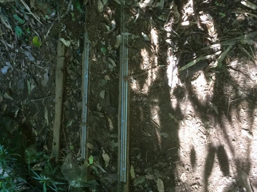
Figure 6 Showing natural surface of track,
Figure 7 Edging strips on steps to
sturdy enclosed shoes, a hat, sunscreen and insect repellent; (d) check weather and local alerts; and (e) download
with rocks, wet ground and tree roots
reduce slips.
the Emergency+ app.
presenting trip and slip hazards.
The effectiveness of these controls, when combined with existing controls, is assessed to be low to medium. The residual risk rating on completion of the Risk Treatment Plan is assessed as medium.
Consequence Rating
Likelihood Rating
Residual Risk Rating
Major (fatality)
Unlikely
Medium
Minor (broken leg/ankle)
Likely
Medium
Wollumbin Summit Track Risk Assessment – Confidential Final Report September 2019
20
 Risk 4 Walker(s) leaving the track and becoming lost leading to serious injury.
Risk
Risk Event
Source
Consequences
Consequence Likelihood
Risk
Existing Controls
Control
Control
Potential
Id
Rating
Rating
Rating
Type
Effectiveness
Exposure
Risk 4 Walker(s) leaving the track and becoming lost leading to serious injury.
Risk
Risk Event
Source
Consequences
Consequence Likelihood
Risk
Existing Controls
Control
Control
Potential
Id
Rating
Rating
Rating
Type
Effectiveness
Exposure
4
Walker(s) leaving the
Visitor behaviour
Serious injury.
Moderate (night
Possible
Medium
General, specific ‘stay on track’ and half-
Administrative
Low
Major
track and becoming
walking)
way safety signage.
Walking in darkness or
Loss of reputation and trust.
lost leading to serious
poor weather
Distance and location information at
injury or.
Minor
Possible
Low
emergency helicopter points.
Well-marked track.
Mobile phone coverage most of track.
Discussion
Wollumbin National Park is a relatively small park and the track is well-marked. A review of WSO, Area records and media reports revealed one rescue of two lost walkers in 2018. The risk of walkers leaving the track,
becoming lost and experiencing a serious injury is assessed to be low for day walking and medium for walking in darkness.
Walkers who leave their attempt too late in the day, or whose trek is slow or delayed, may end up descending the mountain in darkness. In winter the track is dark by 4:30pm.
Walking in darkness increases the risk of
walkers becoming disorientated and losing the track. Ascending in early hours of the morning to summit at dawn is a known bucket list event. During the inspection dawn summiteers on their way down the mountain
were encountered. Camping on the mountain is prohibited to discourage climbing in darkness, but it appears to have little effect.
Field observation
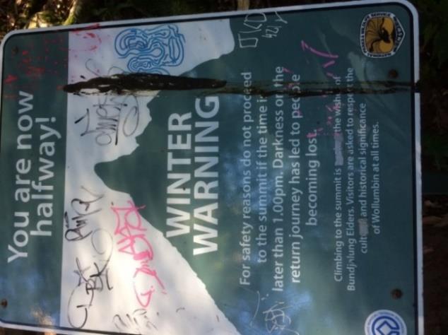
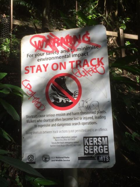
The track is well marked, with regular “Stay on Track” signs (refer to Figure 8) warning
walkers of the risks to safety and the environment of leaving the track. During the risk
assessment inspection, there was little evidence of walkers leaving the track, with the
exception of toilet stops and informal tracks to vantage points. SCU’s (2018) survey
showed that walkers are very summit-focussed, so it is unlikely that many walkers stray far
from the track.
Information signs at the start of the walk warn walkers of walking in darkness, cold weather
at the summit and getting lost; and informs walkers to carry adequate food and water and
wear suitable footwear. To reduce the likelihood of walkers descending the mountain in
darkness, there is an additional warning sign at the half-way point advising walkers to “turn
a back if it is after 1:00pm in winter” (refer to Figure 10).
The Wollumbin Summit Track attraction page on the national parks website is very
thorough providing warnings covering walking in darkness, wet weather, high winds or
thunderstorms; the difficulty of the terrain. It advises walkers to bring water and food and
Figure 8 Stay on track
Figure 9 Emergency Helicopter Point providing
Figure 10 Winter warning sign.
warning sign.
location and distance information.
wear sturdy shoes, suitable clothing, hat, sunscreen, and a first aid kit; and to download the
Emergency+ app and check local alerts before leaving for the walk. A recent update
(30/8/19) to the website provides a link to the online trip intention form.
At the four Emergency Helicopter Points and the helipad on the summit distance and location information is provided (refer to Figure 9). There is mobile phone coverage for most of the track, with the exception of the
start of the track and in Breakfast Creek carpark.
Recommended treatment plan actions
1.
Consider further options to deter predawn summit attempts, such as closing the carpark at night, community education via media and social media, or enforcement blitzes.
2.
Standardise safety messaging on both the walk entry sign and website to: (a) warn walkers of all known risks; to advise walkers to (b) bring water and food, a torch, mobile phone and warm and wet weather
clothing; (c) wear sturdy enclosed shoes, a hat, sunscreen and insect repellent; (d) check weather and local alerts; and (e) download the Emergency+ app.
The effectiveness of these controls, when combined with existing controls, is assessed to be low-medium. The residual risk rating on completion of the Risk Treatment Plan is assessed as low-medium.
Consequence Rating
Likelihood Rating
Residual Risk Rating
Night walking - Moderate
Rare
Medium
Day- walking - Minor
Possible
Low
Wollumbin Summit Track Risk Assessment – Confidential Final Report September 2019
21
Risk 5 Lack of walker skill, experience or health condition leading to serious injury, illness or fatality.
Risk
Risk Event
Source
Consequences
Consequence Likelihood
Risk
Existing Controls
Control Type
Control
Potential
Id
Rating
Rating
Rating
Effectiveness
Exposure
5
Lack of walker skill,
Walker lack of skill,
Serious injury or fatality.
Major (fatality)
Possible
High
General safety, half-way warning and
Administrative
Low
Major
experience or health
experience or health
chain section signage.
condition leading to
condition eg heart attack).
Specific messaging warning of the
serious injury, illness
Minor (broken
Probable
Medium
strenuous climb on attraction website.
or fatality.
leg/ankle)
Well-marked track.
Discussion
At least seven relatively recent visitor safety events relating to health conditions of the walkers were recorded (refer to media reported emergency rescue data, Area records and WSO records listed in Table 4-6). Walker
skill and experience may be a factor in the many slips, trips and falls also recorded. Although the Wollumbin Summit Track attracts a very high number of walkers (170 000 visits annually) with 87% attempting the
summit climb, the climb is very steep in sections and takes between 4-6 hours to complete. It is not suitable for all fitness or accessibility levels. Given that the age profile of summiteers is youth-biased (refer to Table 1
SCU) it may be that less agile or fit walkers do not take on the summit challenge. This self-censorship reduces the risk to themselves and to NPWS.
Field observation
A sign at the start of the walk informs walkers that the walk is 4-5 hour return and is strenuous with a final climb requiring a vertical rock scramble. The website listed the track as Grade 5, ie for very experienced
bushwalkers with specialised skills. However, during the risk assessment inspection trekkers of all skill and fitness levels were encountered.
Information signs at the start of the walk warn walkers of walking in darkness, cold weather at the summit and getting lost; and informs walkers to carry adequate food and water and wear suitable footwear.
The Wollumbin Summit Track attraction page on the national parks website is very thorough providing warnings covering walking in darkness, wet weather, high winds or thunderstorms; the difficulty of the terrain. It
advises walkers to bring or wear water, food, sturdy shoes, suitable clothing, hat, sunscreen, and a first aid kit; to download the Emergency+ app; and check local alerts before leaving for the walk. A recent update
(30/8/19) to the website provides a link to the online trip intention form.
Recommended treatment plan actions
1. Standardise safety messaging on both the walk entry sign and website to: (a) warn walkers of all known risks; to advise walkers to (b) bring water and food, a torch, mobile phone and warm and wet weather
clothing; (c) wear sturdy enclosed shoes, a hat, sunscreen and insect repellent; (d) check weather and local alerts; and (e) download the Emergency+ app.
The effectiveness of these controls, when combined with existing controls, is assessed to be low. The residual risk rating on completion of the Risk Treatment Plan is assessed as high.
Consequence Rating
Likelihood Rating
Residual Risk Rating
Major (fatality)
Possible
High
Minor (injury)
Possible
Low
Wollumbin Summit Track Risk Assessment – Confidential Final Report September 2019
22
Risk 6 Walker(s) exposed to extreme weather (heat, cold, heavy rainfall and thunderstorms) conditions resulting in serious illness (ie heat stroke, heat
exhaustion, dehydration or hypothermia) or serious injury (lightning strike).
Risk
Risk Event
Source
Consequences
Consequence
Likelihood
Risk Rating
Existing Controls
Control Type
Control
Potential
Id
Rating
Rating
Effectiveness
Exposure
6
Walker(s) exposed to extreme
Rapidly changing
Serious illness, injury or
Major (fatality)
Unlikely
Medium
General safety and thunderstorm
Isolation,
Medium
Major
weather (heat, cold, heavy rainfall
weather conditions
fatality.
warning signage.
Administrative &
and thunderstorms) conditions
PPE
High rainfall area
Specific messaging on attraction
resulting in illness (ie heat stroke,
Minor (temporary
Possible
Low
website.
heat exhaustion, dehydration or
Under-prepared
illness)
hypothermia) or serious injury
walkers
Park closure during high rainfall,
(lightning strike).
high wind or total fire ban days.
Discussion
At an altitude of 1070m above sea level, Wollumbin can get surprisingly cold overnight or during heavy rainfall events. Thunderstorms on Wollumbin bring both the risks associated with heavy rainfall and lightning
strike. The warm, humid conditions experienced most of the year places unprepared walkers at risk of heat exhaustion, heat stroke or dehydration. Approximately 80% of the walk is under the tree canopy, which makes
it humid but reduces heat stress from direct radiation.
Walkers on the track will be exposed to the elements (sun, humidity, wind, rain and temperature) which, if not managed, may lead to serious injury.
A review of WSO Area records and media reports revealed one rescue of two walkers in 2017 due to poor weather conditions, and a lightning strike incident in 2016 that resulted in one fatality and another injured. The
risk is assessed as medium.
Field observation
Information signs at the start of the walk warn walkers of walking in darkness, cold weather at the summit and getting lost; and informs walkers to carry adequate food and water and wear suitable footwear.
Specific warning signs advising walkers not to proceed beyond this point during a thunderstorm are in place close to the summit before the chain section.
The Wollumbin Summit Track attraction page on the national parks website is very thorough providing warnings covering walking in darkness, wet weather, high winds or thunderstorms; the difficulty of the terrain. It
advises walkers to bring or wear water, food, sturdy shoes, suitable clothing, hat, sunscreen, and a first aid kit; and to download the Emergency+ app and check local alerts before leaving for the walk. A recent update
(30/8/19) to the website provides a link to the online trip intention form.
Area staff advise that the park access gate is proactively closed in when heavy rainfall events are forecast. This action is directed by the
Visitor Access Management Plan (Tweed-Byron Area, 2019).
Recommended treatment plan actions
1. Standardise safety messaging on both the walk entry sign and website to: (a) warn walkers of all known risks; to advise walkers to (b) bring water and food, a torch, mobile phone and warm and wet weather
clothing; (c) wear sturdy enclosed shoes, a hat, sunscreen and insect repellent; (d) check weather and local alerts; and (e) download the Emergency+ app.
The effectiveness of these controls, when combined with existing controls, is assessed to be low. The residual risk rating on completion of the Risk Treatment Plan is assessed as medium.
Consequence Rating
Likelihood Rating
Residual Risk Rating
Major (fatality)
Unlikely
Medium
Minor (temporary illness)
Possible
Low
Wollumbin Summit Track Risk Assessment – Confidential Final Report September 2019
23
Risk 7 Walker(s) bitten or stung by snakes, spiders, ticks or insects resulting in serious illness or fatality.
Risk
Risk Event
Source
Consequences
Consequence Likelihood
Risk
Existing Controls
Control
Control
Potential
Id
Rating
Rating
Rating
Type
Effectiveness
Exposure
7
Walker(s) bitten or
Snakes, spiders, ticks or
Serious illness or fatality.
Major (fatality)
Rare
Medium
General safety signage.
Administrative
Low
Major
stung by snakes,
insects
& PPE
Well-marked track.
spiders, ticks, etc
resulting in illness or
Insignificant
Likely
Low
Specific information on attraction page
fatality.
(temporary
on website to bring a first aid kit.
illness)
Discussion
The risk of walkers being bitten or stung by snakes, spiders, ticks, leeches etc on the Wollumbin Summit Track is similar to what you expect and accept on most NSW national park walking tracks in rainforest
environments. Of these, snake bite or an allergic reaction to a bite or sting (eg bee sting or tick bite) poses the greatest risk to walkers. The risk is assessed as low to medium.
There are no records from media reports, the Area or WSO of snake or other serious bites or stings requiring medical evacuation.
Field observation
There is advice on website to carry a first aid kit, but not on the walk entry signs. There is no mention of wearing insecticide to protect walkers against leeches or ticks on either the website or park signs. In the event of
bites requiring urgent medical treatment, emergency services may be contacted readily as there is mobile phone coverage for most of the track.
Recommended treatment plan actions
1. Standardise safety messaging on both the walk entry sign and website to: (a) warn walkers of all known risks; to advise walkers to (b) bring water and food, a torch, mobile phone and warm and wet weather
clothing; (c) wear sturdy enclosed shoes, a hat, sunscreen and insect repellent; (d) check weather and local alerts; and (e) download the Emergency+ app.
The effectiveness of these controls, when combined with existing controls, is assessed to be low. The residual risk rating on completion of the Risk Treatment Plan is assessed as medium.
Consequence Rating
Likelihood Rating
Residual Risk Rating
Major (fatality)
Rare
Medium
Insignificant (temporary illness)
Likely
Low
Wollumbin Summit Track Risk Assessment – Confidential Final Report September 2019
24
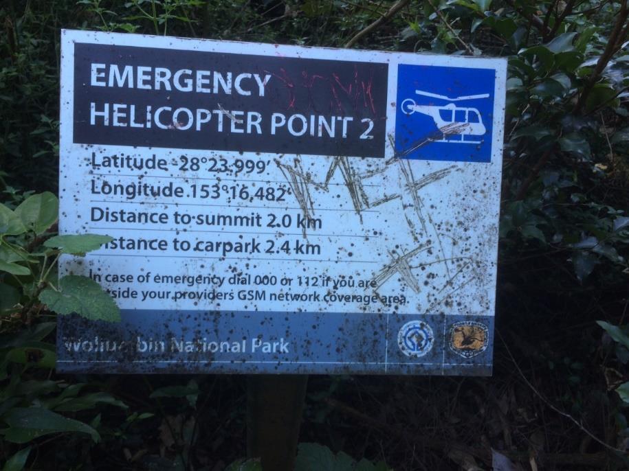 Risk 8 Delays in emergency response to lost or injured walker(s).
Risk
Risk Event
Source
Consequences
Consequence Likelihood
Risk
Existing Controls
Control
Control
Potential
Id
Rating
Rating
Rating
Type
Effectiveness
Exposure
Risk 8 Delays in emergency response to lost or injured walker(s).
Risk
Risk Event
Source
Consequences
Consequence Likelihood
Risk
Existing Controls
Control
Control
Potential
Id
Rating
Rating
Rating
Type
Effectiveness
Exposure
8
Delays in emergency
Poor weather restricting helicopter
Serious injury or
Major (fatality
Rare
Medium
Mobile phone coverage most of track.
Engineering &
Medium
Catastrophic
response to lost or
access
fatality.
Administrative
Safety and locational signage.
injured walker(s)
Terrain and closed forest
Loss of reputation and
endangering patient
4 Emergency Helicopter Points and helipad
trust.
survival.
Mobile phone blackspots
at summit.
Disruptions to normal mobile
Emergency service personnel regularly
coverage
deployed on Wollumbin rescues
(experienced).
Relatively close proximity to emergency
services and hospitals.
VRA for ground-based rescues.
High visitation levels.
Discussion
The risk of delays in emergency response to lost of injured walkers endangering patient survival is assessed as medium.
Wollumbin National Park is situated close to emergency response services. The Police, State Emergency Service and Ambulance Service are available for tasking from Murwillumbah. Volunteer Rescue Association,
Patients with serious injuries are airlifted to the Gold Coast Hospital. Less serious cases to Murwillumbah Hospital. The Westpac Rescue Helicopter is tasked out of nearby Lismore.
Rescue response records in Tables 4-6 show that air and land-based rescues on the Wollumbin Summit Track are common, and hence, the local emergency services are very experienced in undertaking these rescues.
NPWS could consider closing the Wollumbin Summit Track on low visibility days, but with the limited data available this seems unnecessary. It would place an additional resource burden on NPWS. The local Volunteer
Rescue Authority, Police, State Emergency Service and Ambulance Service have proven proficient in undertaking ground-based rescues when helicopter access is restricted.
Field observation
One problem is that whilst mobile phone coverage is available for most of the track, it is not available at the Breakfast Creek carpark (ie start of track).
Walkers who choose to descend to the carpark before attempting to call emergency services will find that they cannot. The Breakfast Creek carpark is a
logical place to coordinate an incident response but the lack of mobile phone coverage in the carpark would frustrate efforts and may delay emergency
responses.
Information signs at the start of the walk warn walkers of walking in darkness, cold weather at the summit and getting lost; and informs walkers to carry
adequate food and water and wear suitable footwear.
The Wollumbin Summit Track attraction page on the national parks website is very thorough providing warnings covering walking in darkness, wet
weather, high winds or thunderstorms; the difficulty of the terrain. It advises walkers to bring or wear water, food, sturdy shoes, suitable clothing, hat,
sunscreen, and a first aid kit; and to download the Emergency+ app and check local alerts before leaving for the walk. A recent update (30/8/19) to the
website provides a link to the online trip intention form.
Recommended treatment plan actions
1. Standardise safety messaging on both the walk entry sign and website to: (a) warn walkers of all known risks including poor or no mobile phone
reception in carpark and other areas; to advise walkers to (b) bring water and food, a torch, mobile phone and warm and wet weather clothing; (c) wear
sturdy enclosed shoes, a hat, sunscreen and insect repellent; (d) check weather and local alerts; and (e) download the Emergency+ app.
2. Consider boosting mobile coverage at Breakfast Creek carpark or update track head signs to advise where mobile phone coverage is available.
Figure 11 Emergency Helicopter Point 2.
The effectiveness of these controls, when combined with existing controls, is assessed to be medium. The residual risk rating on completion of the Risk Treatment Plan is assessed as medium.
Consequence Rating
Likelihood Rating
Residual Risk Rating
Major (fatality)
Rare
Medium
Wollumbin Summit Track Risk Assessment – Confidential Final Report September 2019
25
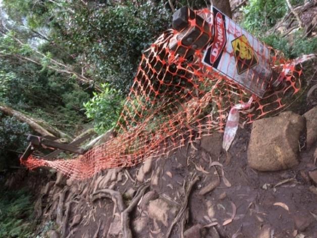
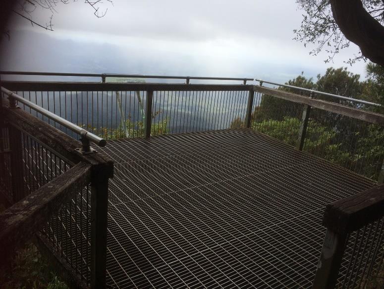 Risk 9 Built asset (elevated platforms, handrails, constructed pathway) failure causing serious injury or fatality to walker(s).
Risk
Risk Event
Source
Consequences
Consequence Likelihood
Risk
Existing Controls
Control
Control
Potential
Id
Rating
Rating
Rating
Type
Effectiveness
Exposure
Risk 9 Built asset (elevated platforms, handrails, constructed pathway) failure causing serious injury or fatality to walker(s).
Risk
Risk Event
Source
Consequences
Consequence Likelihood
Risk
Existing Controls
Control
Control
Potential
Id
Rating
Rating
Rating
Type
Effectiveness
Exposure
9
Built asset (elevated
Poor design
Serious injury or fatality.
Catastrophic
Rare
Medium
5-yearly engineering inspections of
Engineering &
Medium
Catastrophic
platforms, handrails,
(multiple
elevated platforms.
Administrative
(Extreme)
Insufficient maintenance
Loss of reputation and trust.
constructed pathway)
fatalities)
Regular 3-6-monthly inspection and
failure causing serious
Overuse
maintenance by field staff.
injury or fatality to
Major (fatality)
walker(s).
Vandalism
Unlikely
Medium
Staff respond to visitor reports of
asset damage.
Minor (broken
Possible
Low
leg/ankle)
Discussion
The track has a wide range of constructed infrastructure from elevated viewing platforms at the summit to bridges, emergency helicopter points, decking board, signs, seats, steps handrails and the chain section (see
Figures 12 - 15). The greatest risk is failure of an elevated platform where multiple people congregate. These structures at the summit would be under the most stress during peak visitation periods (eg New Year’s Day)
where overcrowding on the track occurs. This risk has been assessed as medium.
Area staff advise that built asset inspections are undertaken quarterly or following heavy rainfall or storms or prior to events. Also covered in monthly general inspections. Area staff advise that AMS is used to record
these inspections. An AMS report for 2010-19 records that the last 5-yearly engineering inspection of the viewing platforms occurred on 26/4/16 and the pedestrian bridges on 1/3/18. Pedestrian bridge inspections
appear to be occurring 6-montly. Area staff advise that the 5-yearly engineering reports are filed to AMS. Recent reports for the elevated platforms were sighted in AMS (Lucena, 2019). Quarterly general inspections are
recorded in AMS, but no specific record of quarterly built asset inspections.
Field observation
Generally, the handrails and superstructure of the viewing platforms appear to be in good condition and well maintained. But the condition of signs,
handrails, etc appeared to deteriorate closer to the summit. It appeared that maintenance frequency in this section of the track is low. Examples
included graffitied and dirty signs at the summit, missing handrails, sections of chain and barricade tape laying slack.
Area staff advised that viewing platforms at the summit were to be upgraded but this has not yet happened due to opposition from the Wollumbin
Consultative Group on building structures or allowing access to the Wollumbin summit. These structures should be part of a cyclic inspection and
maintenance regime in AMS. The poor condition of the interpretation signs on the summit and along the track puts into doubt whether this is occurring.
At the Emergency Helicopter Points walkers stop and congregate to rest, enjoy the views and take photographs. These sites are small clearings on
the edge of the slope allowing helicopters to winch injured walkers to safety. There are no barriers to stop walkers from falling from these points. It is
acknowledged that barriers at these sites may impede winching operations.
Recommended treatment plan actions
Figure 13 Barrier fencing
1. Reinstall failed sections of barrier fencing at other locations (eg see Figure 13 – between Emergency Helicopter Points 3 and 4).
and temporary exclusion
Figure 12 Low slip decking.
tape not maintained.
Note: Area staff advise (6/9/19 that the damaged handrails were removed).
2. Upgrade handrails and other proposed works on the summit viewing platforms in accordance with recommendations from the 5-yearly engineering
inspections.
The effectiveness of these controls, when combined with existing controls, is assessed to be medium to high. The residual risk rating on completion of the Risk
Treatment Plan is assessed as medium.
Consequence Rating
Likelihood Rating
Residual Risk Rating
Catastrophic (multiple fatalities)
Rare
Medium
Major (fatality)
Rare
Medium
Figure 14 Elevated viewing platform on the summit.
Minor (broken leg/ankle)
Unlikely
Low
Wollumbin Summit Track Risk Assessment – Confidential Final Report September 2019
26
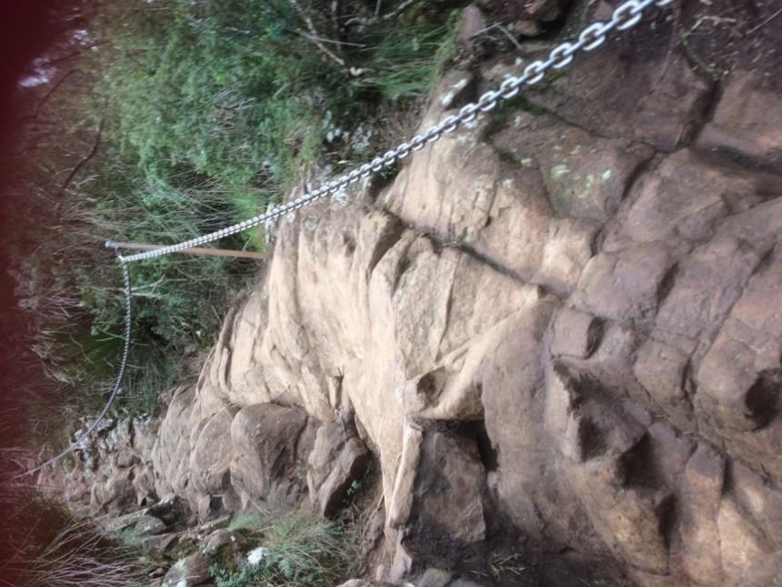
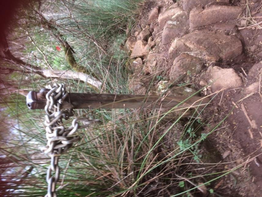 Risk 10 Failure of the chain and anchor system causing serious injury or fatality to walker(s).
Risk
Risk Event
Source
Consequences
Consequence Likelihood
Risk
Existing Controls
Control
Control
Potential
Id
Rating
Rating
Rating
Type
Effectiveness
Exposure
Risk 10 Failure of the chain and anchor system causing serious injury or fatality to walker(s).
Risk
Risk Event
Source
Consequences
Consequence Likelihood
Risk
Existing Controls
Control
Control
Potential
Id
Rating
Rating
Rating
Type
Effectiveness
Exposure
10
Failure of the chain and
Poor design
Serious injury or fatality.
Catastrophic
Rare1
Medium2
Regular inspection and maintenance
Engineering &
Medium
Catastrophic
anchor system causing
(multiple
by field staff.
Administrative
(Extreme)
Insufficient maintenance
Loss of reputation and trust.
serious injury or fatality
fatalities)
to walker(s).
Overcrowding - too many
Temporary or permanent
walkers on the chain
closure of the track.
Major (fatality)
Medium
Unlikely
section
Overuse
Minor (broken
Medium
Possible
Vandalism
leg/ankle)
Note: Using the risk matrix in
Quick Reference Guide – Asset Performance Assessments – Walking tracks and elevated structures (Table 2 assessment of risk and barrier location) yielded 1 (Likely) and 2 (Extreme). However, given that there are no recorded incidents
of this magnitude, we have used the OEH Health & Safety Risk Matrix ratings.
Discussion
The track contains a chain section commencing about 30mins from the summit for a length of approximately 100m.
The track is a Class 3 track (as assessed under AS2516.1-2001). Built elements on Class 3 tracks should be inspected at intervals of 6 months or less, be regularly maintained, and managed for public risk. Under the
NPWS cyclic maintenance program, inspections and maintenance on the chains are carried out every 3 months by NPWS staff.
Under AS 2156.2—2001 (Standards Australia 2001b) provides guidance on fall prevention devices for walking track structures. The natural rockface at the Wollumbin summit is not a structure, so the expectations of
AS2156.1 do not apply.
There are no records of injuries directly attributed to failure of the chain and anchor system. Any load rating or warranty on the chain or post anchors is not known. Area staff advise anecdotally of D shackles failing, and
then being fixed.
Field observation
The chain appears to be constructed of mild steel and is attached to steel posts placed largely perpendicular to the rockface.
The posts are dug into the rock or earth surface. The chain is attached to the posts with D shackles. The chain is used to
provide balance and handholds for walkers negotiating the final ascent to the summit.
Review of AMS did not show any engineering assessment of the chain section. Area staff confirmed that no engineering
assessment had occurred within the last 5 years. Cyclic inspections and maintenance of the chain is being recorded in AMS.
Recent inspections were quarterly with last inspection on 1/9/19.
The condition of signs, handrails, etc appeared to deteriorate closer to the summit. It appeared that maintenance frequency in
this section of the track is lesser. Examples included graffitied and dirty signs at the summit, missing handrails, sections of
chain and barricade tape laying slack. Erosion of the track surface would be a constant hazard due to its high use and high
rainfall.
Recommended treatment plan actions
1. Commission an engineering assessment of the chain and anchor system to determine its capacity to meet expected live
loads, its condition and recommend a maintenance regime.
2. Implement agreed recommendations arising from the engineering assessment.
3. Area staff manage walker access on peak visitation periods/days.
Figure 15 End post and chain.
Figure 16 Chain section looking upwards.
4. Reinstate loose and unattached lengths of chain.
5. Update signage to advise on the best way to use the chain ascending and descending.
6.
Consider the benefits and risks associated with Installing an additional chain on the other side of the track to cater for many walkers on the track, avoid confusion on the safest route and to allow for the separation
of ascenders and descenders.
7.
Provide an alternative to climbing the rockface to the summit, such as a loop walk around the mountain to minimise risks to visitor safety and to the cultural sensitivity of the site.
The effectiveness of these controls, when combined with existing controls, is assessed to be medium to high. The residual risk rating on completion of the Risk Treatment Plan is assessed as medium.
Wollumbin Summit Track Risk Assessment – Confidential Final Report September 2019
27
Consequence Rating
Likelihood Rating
Residual Risk Rating
Catastrophic (multiple fatalities)
Rare
Medium
Major (fatality)
Unlikely
Medium
Minor (broken leg/ankle)
Possible
Medium
Wollumbin Summit Track Risk Assessment – Confidential Final Report September 2019
28
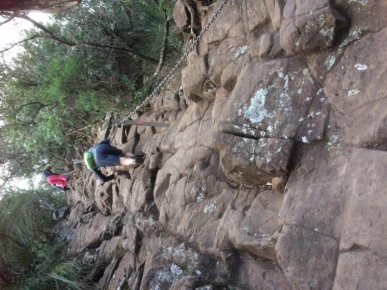
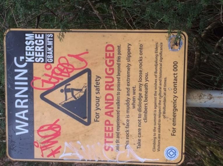
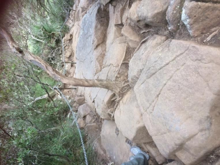 Risk 11 Slips, trips or falls ascending and descending the chain section causing serious injury or fatality to walker(s).
Risk
Risk Event
Source
Consequences
Consequence Likelihood
Risk
Existing Controls
Control
Control
Potential
Id
Rating
Rating
Rating
Type
Effectiveness
Exposure
Risk 11 Slips, trips or falls ascending and descending the chain section causing serious injury or fatality to walker(s).
Risk
Risk Event
Source
Consequences
Consequence Likelihood
Risk
Existing Controls
Control
Control
Potential
Id
Rating
Rating
Rating
Type
Effectiveness
Exposure
11
Slips, trips or falls
Overcrowding - too many
Serious injury or fatality.
Catastrophic
Rare
Medium
The chain and anchor system.
Engineering,
Medium
Catastrophic
ascending and
walkers on the chain
(multiple
Administrative
(Extreme)
Loss of reputation and trust.
descending the chain
section
fatalities)
& PPE
section causing
Poor visitor behaviour
serious injury or
fatality to walker(s).
Possible
High
Steepness of the terrain
Major (fatality)
Specific safety signage at the chain
section.
Wet weather
Poor design
Minor (broken
Probable
High
Park closure during high rainfall events.
leg/ankle)
Insufficient maintenance
Discussion
With 170 000 visitors to the Wollumbin Summit Track and 87% of those reaching the summit is it surprising that there have not been more reported serious injuries or fatalities. The chain section presents a physical and
psychological challenge to walkers because of the steepness of the rock/slope and the height. Falls from the chain section to its base many metres below could be fatal. During busy times, a falling walker could knock
others over increasing the likelihood of multiple serious injuries or fatalities.
Data from Tables 5 and 6 indicate that there were three events resulting in injuries requiring rescue in the chain section/summit between 2010 and August 2019 (on 8/8/14, 8/7/17 and 8/8/19). In addition, during the
same period, two cases of fatigue (on 9/7/17 and 28/3/6) and one case of seizure (on 26/6/18) requiring rescue from the summit were recorded. This small number of incidents is likely to be an underestimate with no
location identifier for 16 out of the 40 recorded incidents in Tables 4-6.
Visitation patterns are not uniform and during weekends, holiday periods and New Year’s Eve visitation levels increase dramatically. Walkers amass at the base of the chain section. Overcrowding on the chain section
increases the likelihood of walkers overtaking other walkers by ascending the track without the aid of the chain, dislodging loose rocks on walkers below or panicking slower walkers on the chain.
NJK Consulting Engineers (2016), when undertaking an assessment of the elevated structures on the summit track, commented on the risks to walkers using the chains to ascend the final 50-100m of track. They
recommended that a suspended walkway/stairway be constructed to replace the chain and post balustrade system.
Field observation
Figures 14 – 18 show the chain section, specifically the chain, anchor posts and shackles; visitors ascending and descending; the terrain and safety warning signs.
The chain, D shackles and posts all appear to be in good condition.
Sections of chain had been placed out of service and were left lying on the ground or wrapped around a post. The reason for the removal of these sections of chain is unknown.
Groups of young friends (20s), couples (in their 40s, 50s and 60s), and families (with school-aged
children) were using the chain section on the risk assessment inspection day. Their experiences
tackling this section of the track were observed. The estimated fitness levels ranged from very fit
(trail runners) to the relatively unfit. Many walkers were dressed in only light clothing and carrying
only a water bottle.
The chain runs up one side of the track. For some the chain is not located adjacent to the easiest
route up the rockface. This situation places walkers in a dilemma – stay on the chain or move off
it to the easier route. Placing the chain along one side of the track was probably a convenience of
construction.
There is no separation of walkers ascending and descending so walkers must push past each
other on the chain.
The chain appears to be slung too low for effective use on the descent. Walkers appeared unsure
whether to go back down backwards or forwards. Walkers were observed getting their backpacks
caught up in the chain.
The footholds carved into the rock are too far apart for walkers with shorter legs. It appeared
easier to descend backwards in some sections but the gap between footholds made it difficult.
Figure 16 Ascending climbers
Figure 17 Warning sign at the
Figure 18 View of chain
on the chain section.
base of chain section.
section from above.
Walkers were generally respectful of others on the chain. But it was a winter Tuesday morning
(18/6/2019), outside of holiday time so numbers were lower. Those visitors using the mountain for
fitness training appeared less willing to wait their turn and instead overtook other walkers by avoiding the chain.
The warning sign at the base of the chain section warns walkers that only ‘fit and experienced walkers’ should proceed. This warning appeared to be ignored with most walkers attempting the final summit climb.
Wollumbin Summit Track Risk Assessment – Confidential Final Report September 2019
29
Recommended treatment plan actions
1. Update signage to advise on the best way to use the chain ascending and descending.
2. Consider the merits of installing an additional chain on the other side of the track to cater for many walkers on the track, avoid confusion on the safest route and to allow for the separation of ascenders and
descenders.
3. Area staff manage walker access on peak visitation periods/days.
The effectiveness of these controls, when combined with existing controls, is assessed to be medium to high. The residual risk rating on completion of the Risk Treatment Plan is assessed as medium.
Consequence Rating
Likelihood Rating
Residual Risk Rating
Catastrophic (multiple fatalities)
Rare
Medium
Major (fatality)
Possible
High
Minor (broken leg/ankle)
Probable
High
Wollumbin Summit Track Risk Assessment – Confidential Final Report September 2019
30
10. REFERENCES
Australian Standard AS 2156.1—2001
Walking tracks Part 1: Classification and signage
Australian Standard AS 2156.2—2001
Walking tracks: Infrastructure design
Australian Walking Track Grading System.
Civil Liability Act, 2002.
GHD, 2018.
Wollumbin (Mt Warning) summit track slope stability assessment.
Northern Star newspaper (6/12/16).
Lucena Civil & Structural Engineers, 2019.
Assessment of the condition of existing balustrades at Mt
Warning Lookout.
NJK Consulting Engineers, 2016.
Structural Engineer Investigation Report. National Parks and
Wildlife Services – Elevated Structures Project.
NPWS Quick Reference Guide – Asset Performance Assessments – Walking tracks and elevated
structures.
NPWS, 2004.
Parks and Reserves of the Tweed Caldera Plan of Management.
NPWS Tweed Byron Area, 2019.
Wollumbin Summit Walking Track, Wollumbin National Park
Visitor Access Management Plan 2019
NPWS,
2013.
Tree Risk Management Policy and Procedures
NPWS, 2017.
NPWS Visitor Safety Policy and Procedures
NPWS, 2017.
Asset Inspection & Performance Assessment Guidelines - Walking Track &
Components.
OEH, 2017.
OEH Health & Safety Risk Matrix.
OEH 2018.
OEH Risk Management Policy.
OEH, 2019.
OEH Risk Management Procedures.
Southern Cross University, 2018.
Alternative to Summiting Wollumbin – Research Findings &
Implications. (Presentation delivered 23/11/18 to the Northcoast Branch Regional Advisory
Committee.)
Wollumbin Summit Track attraction page – NSW national parks website.
Work Health and Safety Act 2011.
 APPENDIX 1: HEALTH & SAFETY MATRIX
Wollumbin Summit Track Risk Assessment
APPENDIX 1: HEALTH & SAFETY MATRIX
Wollumbin Summit Track Risk Assessment – Confidential Final Report September 2019
32